

Trails in the
Hocking Hills
The BENCAD Trail from Old Man's Cave to Ash Cave is also named the Grandma Gatewood Trail. Grandma Gatewood was an Ohioan who was on the board of the Buckeye Trail Association, and who was the first woman to hike the entire Appalachian Trail solo around six decades ago.
Menu
- Accessible Trails
- Visitors' Center
- Hockhocking Expedition Trail
- Bluebird Trail
- BENCAD Trail
- Kreashbaum Road Section: 3.5 miles
- Big Pine Road Section: 1.9 miles
- Rock Climbing Area Section: 2.0 miles
- Rock Climbing Area Trails
- Rock Climbing Area Horse Bypass: 0.6 mile
- Culp Road Section: 1.4 miles
- Grandma Gatewood Trail: 4.7 miles
- Grandma Gatewood Trail, Old Man's Cave to Cedar Falls: 2.8 miles
- Grandma Gatewood Trail, Old Man's Cave Section: 0.5 mile
- Grandma Gatewood Trail, Queer Creek Section: 2.3 miles
- Grandma Gatewood Trail, Cedar Falls to Ash Cave: 1.9 miles
- Grandma Gatewood Trail, Cedar Falls Section: 0.7 mile
- Grandma Gatewood Trail, Upper Ash Cave Section: 0.9 mile
- Grandma Gatewood Trail, Lower Ash Cave Section: 0.3 mile
- Hocking Hills Bypass Trail, Gorge Bypass Section: 2.5 miles
- Hocking Hills Bypass Trail, Ash Cave Bypass Section: 2.6 miles
- Gorge Rim Trail: 3.1 miles
- Gorge Overview Trail: 0.2 mile
- Rose Lake Trails
- Rose Lake Trail: 0.5 mile
- Campground Connector Trail: 0.4 mile
- Rose Lake Loop Trail: 1.0 mile
- Conkles Hollow Trails
- Conkles Hollow Gorge Trail: 0.6 mile
- Conkles Hollow Rim Trail: 2.0 miles
- Horse Trails: 47 miles
- Red Horse Trail: 5.1 miles
- Purple Horse Trail: 4.6 miles
- Orange Horse Trail: 4.5 miles
- White Horse Trails: 19 miles
- BENCAD Trail for Horses: 13.8 miles
- Mountain-Biking Trails: 3.3 miles combined 0-loop; 3.8 miles combined 8-loop
- Orange Bike Trail: 1.9 miles
- Purple Bike Trail: 1.9 miles
- Archery Trail: 0.25 mile
- Accessible Trails: There are several fully-accessible trails (accessible to people in wheelchairs and with other disabilities) in the Hocking Hills Area. See the Hockhocking Expedition Trail, the Grandma Gatewood Trail, Lower Ash Cave Section, and the Conkles Hollow Gorge Trail.
- Visitors' Center: The BENCAD Trail, the Hocking Hills Bypass Trail, the Gorge Rim Trail, and the Grandma Gatewood Trail all converge at the Visitors' Center on OH-664 at Culp Road. In addition, there are two short trails at the center:
- Hockhocking Expedition Trail: A short, completely accessible paved loop adjacent to the Visitors' Center with interpretive facilities and several pens with local birds of prey (these are injured birds).
- Bluebird Trail: This is a short mown trail at the edge of the woods, providing an additional link between the Hockhocking Expedition Trail and the Hocking Hills Bypass Trail, with several bluebird houses along the route.
- BENCAD Trail: 13.5 miles on the blue-blazed trailway from Starr Route Road to Ash Cave. The BENCAD Trail: (Buckeye - North Country - American Discovery Trail) is fully combined through the Hocking Hills, so the blanket BENCAD Trail name is used.
- Kreashbaum Road Section: 3.5 miles. Blazed in light blue. This section of the trail starts at Starr Route Road, Hocking County Road 4, at the north end of the Hocking Hills (north/east of here, the trail is on roads for a considerable distance). It extends south on the hillsides, winding in and out of coves, but always below the bluff line, to Kreashbaum Road, County Road 9, close to Big Pine Road, County Road 11. This off-road section mostly parallels Kreashbaum Road, which is farther into the valley. Going south to north (from the parking area on Kreashbaum Road), it crosses Rocky Ford Road, Township Road 232, at 2.5 miles, then crosses Kreashbaum Road at 2.9 miles, and a private drive at 3.0 miles. This is a lightly-traveled but quite beautiful section of trail, with many rock features. To reach the parking area, take OH-664 south from US-33 to Big Pine Road, turn right and go to Kreashbaum Road, then turn right. The parking area will be on your right.
- Big Pine Road Section: 1.9 miles. Blazed in light blue. This section is on-road, first Kreashbaum Road for 0.3 mile, then Big Pine Road to 1.6 miles, to the turnoff for the rock-climbing area. The trail formerly was off-road in this stretch, but it crossed two nature preserves that were created several decades ago, and since these preserves are not open to the public, the trail was re-routed onto the roads. However, the walk along these roads is very pleasant, and traffic is light. Parking at the rock-climbing area.
- Rock-Climbing Area Section: 2.0 miles. Blazed in light blue. This section is off-road, from Big Pine Road, County Road 11, to Unger Road, Township Road 59A. It starts at the rock-climbing area entrance, crosses a side-stream to Big Pine Run, then climbs the hillside via several switchbacks to the base of the bluffs. At this point, it enters a beautiful and intriguing area, as it ascends between the main bluff and outlying monoliths that have broken off the bluff. At the very top of the bluff, there is a place to tie up horses. Continuing along the top of the bluff, the trail eventually crosses a stream just above a high waterfall. At this point, 0.6 mile from Big Pine Road, the horse bypass departs uphill to the left. ALL HORSES MUST TAKE THIS BYPASS. NO HORSES ARE ALLOWED ON THE CLIFF-EDGE TRAIL FROM THIS POINT. Not only is the cliff-edge trail very dangerous for horses, but there were serious problems in the past with horses stepping on climbing ropes before the bypass was created. At another stream which becomes another high waterfall, the trail turns south, upstream, and the bypass rejoins it at 1.3 miles from Big Pine Road. From this point, the trail climbs uphill through a pine forest and follows the ridgetop to a point close to private property, where it then follows the hillside until the Unger Road crossing. Parking is available at the Rock-Climbing Area parking lot on Big Pine Road.
- Rock-Climbing Area Trails: Several short trails loop off the BENCAD Trail below the cliffs to provide access to the cliffs for rock-climbing and rappelling. These provide access to beautiful scenery even if you're not climbing; the cliffs here are also fairly high.
- Rock-Climbing Area Bypass Section: 0.6 mile. Blazed in white. Starting from the BENCAD Trail at a point 0.6 mile southeast of Big Pine Road, this horse bypass climbs the hill, then gradually descends back to the BENCAD Trail at a point 1.3 miles from Big Pine Road. Length of bypass is 0.6 mile, so it actually cuts off about 0.1 mile from the BENCAD route.
- Culp Road Section: 1.4 miles. Blazed in light blue. Starting from Unger Road, Township Road 59A, the trail descends into a small stream valley, crosses the stream, climbs over the next ridge, crosses the next stream, then climbs over the next ridge to Culp Road, Township Road 251, at a point about 1.1 miles from Unger Road. It then parallels the road for another 0.3 mile to OH-664 at Old Man's Cave, and to the visitors' center. This entire section is above the bluff line, so slopes are fairly gentle and few rock features are seen. Parking is available at Old Man's Cave on OH-664.
- Grandma Gatewood Trail: From Old Man's Cave to Cedar Falls is 2.8 miles. From Cedar Falls to Ash Cave is 1.9 miles. Total 4.7 miles.
- Grandma Gatewood Trail, Old Man's Cave Section: 0.5 mile. Blazed in blue (but not with tree blazes, but with blue lines around random trail-side posts). This section begins at OH-664 at the visitors' center. It descends into the gorge at the Upper Falls, and follows the gorge to the Lower Falls, where the Old Man's Cave Trail (but not the BENCAD Trail) climbs back out via a long stone stairway in a tunnel. However, it's still fun to climb out of the gorge, go to the overlook, then climb back down to the trail. This section of the trail is highly developed, with 8 bridges, stone steps, and paved walkway. This is one of the most scenic sections of any trail in the entire state, but, unfortunately, no effective access control off the trail was provided when the trail was rebuilt around the turn of the century, so the flora in the bottom of the Old Man's Cave Gorge is absolutely devastated, although IT IS ILLEGAL TO GO OFF-TRAIL WITHIN THE HOCKING HILLS STATE PARK, AND YOU CAN BE TICKETED AND FINED.
- Grandma Gatewood Trail, Queer Creek Gorge Section: 2.3 miles. Blazed in blue (but not with tree blazes, but with blue lines around random trail-side posts). This section descends through the remainder of the Old Man's Cave Run Gorge, then ascends through the gorge of Queer Creek to Cedar Falls. It is in many places a fairly well-developed trail, but there are many spots that are tricky or even hazardous. The trail cannot just follow an even path along the stream, because bluffs keep intruding, so it several times climbs and descends a big. When getting close to Cedar Falls, the trail crosses the stream on three bridges, then ascends out of the gorge on a narrow trailway that is squeezed between an overhanging bluff and outlying rocks, to a side stream, where the bridge was washed out but which is normally easy to cross. Then it ascends via a long stretch of graded steps to the Cedar Falls entry road. Two other routes may be taken out of the gorge. At the first bridtge encountered, another trail may be taken by bearing to the right, and this ascends a long series of graded steps and trailway to the entry road. The other way out is by turning left right at Cedar Falls and going up series of flights of wooden steps to the top, where the Gorge Rim Trail and the Bypass Trail can be taken. Parking is available either at Old Man's Cave or at Cedar Falls.
- Grandma Gatewood Trail, Cedar Falls Section: 0.7 mile. Blazed in blue (but not with tree blazes, but with blue lines around random trail-side posts). This section ascends through a side-stream valley, above the bluff line, to Chapel Ridge Road, County Road 255. Parking available at Cedar Falls.
- Grandma Gatewood Trail, Upper Ash Cave Section: 0.9 mile. Blazed in blue. This section descends from Chapel Ridge Road through the stream valley that feeds Ash Cave, to Ash Cave. It is entirely above the bluff line until it actually reaches Ash Cave. Parking available at Ash Cave.
- Grandma Gatewood Trail, Lower Ash Cave Section: 0.3 mile. This is the section of the trail that descends from Ash Cave itself to the Ash Cave parking area. Most of this section is handicapped-accessible. Ash Cave is possibly the biggest rockhouse in southeast Ohio. It is a beautiful location that has been used as the site for many weddings. Parking available at Ash Cave.
- Hocking Hills Bypass Trail, Gorge Bypass Section: 2.5 miles. Blazed in white. This is the horse bypass for the BENCAD Trail throught the gorge, where it is the Grandma Gatewood Trail. From the point at which the BENCAD Trail crosses OH-664, this trail diverges, passing northeast of the visitors' center, then crossing Old Man's Run well above the gorge (warning: no bridge, somewhat difficult to cross for hikers), then ascends the ridge, crosses the campground road, then follows the hillside paralleling OH-374, crossing the Rose Lake Trail, which is NOT open to horses, then descending and joining the Gorge Rim Trail just northwest of Cedar Falls. At the suspension bridge, the Bypass Trail continues straight (whereas the Rim Trail crosses the bridge), to OH-374, then along the shoulder of the road to the parking area at the suspension bridge. Parking is available at the suspension bridge.
- Hocking Hills Bypass Trail, Ash Cave Bypass Section: 2.6 miles. Blazed in white. Goes through the Hocking State Forest above the bluff line, parallelling Blind Road, Township Road 273, for about 0.4 mile, and then along OH-56 for 0.4 mile at the end to Ash Cave. Parking available at the suspension bridge or at Ash Cave.
- Gorge Rim Trail: 3.1 miles. Blazed in red (but not with tree blazes, but with blue lines around random trail-side posts). Mostly a well-developed trail, wide, winding along the hillside above the gorge rim. At Rose Lake, which was built well after the original Rim Trail, it leaves its former path to ascend to cross the dam. It intersects with the "20-kilometer" Trail, the Rose Lakeside Trail, the Hocking Hills Bypass Trail, and the Upper Gorge Edge Trail. It also connects to the high A-frame bridge that crosses Old Man's Cave Gorge near the interpretive center. Mostly an easy trail. Parking available at Old Man's Cave, at Cedar Falls, and at the Suspension Bridge.
- Upper Gorge Edge Trail: 0.2 mile. This is a short trail that departs from the Gorge Rim Trail along upper Old Man's Cave Gorge, down to the A-frame bridge. It goes much closer to the gorge rim than does the Gorge Rim Trail. Exercise extreme caution on this trail! Parking available at Old Man's Cave.
- Rose Lake Trails: Rose Lake is the 17-acre lake close to the main camping area. It is the focal point of a minor trail system, extending from the Gorge Rim Trail, which passes across the dam.
- Rose Lake Trail: 0.5 mile. Extending from fisherman's parking area on OH-374 to Rose Lake. Foot travel only. From the parking area, atop the ridge, it extends along the ridgetop then descends to the 20-kilometer trail.
- Campground Connector Trail: This is a short trail, about 3/8 mile, connecting the head of Rose Lake with the campground. Intersects with the Rose Lake Loop Trail.
- Rose Lake Loop Trail: 1.0 mile. This extends from the Gorge Rim Trail along the eastern side of Rose Lake, then bacl to the Gorge Rim Trail on the west side of the lake. It is garishly blazed on the east side, both with paint and with flagging tape. There are occasional posts with the legend "20 K" and one post with the legend "9 mi." This trail is well-cleared on the east side of the lake, somewhat cleared on the west side, but not developed, and is annoying to hike. At the head of the lake, it intersects with the Campground Connector Trail, and there is a wildlife-viewing blind building there.
- Conkles Hollow: Conkles Hollow is a state nature preserve that offers two great trail opportunities.
- Conkles Hollow Gorge Trail: 0.5 mile. This is a trail that extends from the parking area on Big Pine Road up into the upper end of the gorge, below the waterfall. It is pave and fully accessible for most of its length, except for a short section at the upper end. This trail is very easy, and is an absolute must-do in the Hocking Hills, with the deepest gorge and the highest cliffs.
- Conkles Hollow Rim Trail: 2.0 miles. This trail extends from the Conkles Hollow parking area on Big Pine Road up and around the entire rim of Conkles Hollow. On the east side, hikers can also access horse trails, including the Orange Trail to Airplane Rock.
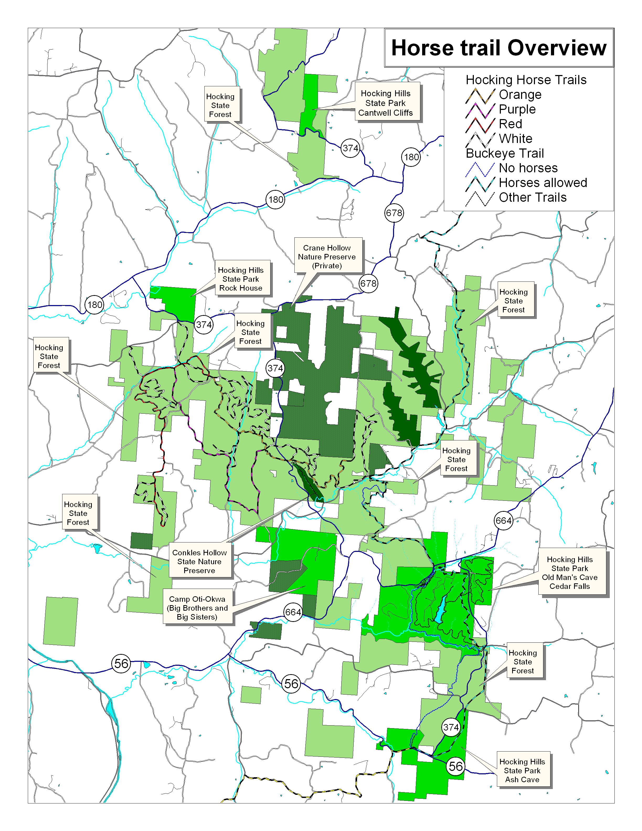
- Horse Trails: 47 miles. The State Forest offers a network of horse trails, with miles, but these are supplemented by the BENCAD Trail and its bypasses. Horses are allowed on all of the BENCAD Trail north of OH-664 except for the rock-climbing area, where a bypass is provided; south of OH-664, there is a bypass provided down to Ash Cave. These bypasses are blazed in white, and a very short section is combined with the Gorge Rim Trail, blazed in red, near Cedar Falls. The ONLY horse trailer parking available is at the horse camp. The horse trail overview map is below this section.
- Red Horse Trail: 5.1 miles. Blazed in red. This trail starts at the horse camp, then descends via a small valley to Little Pine Creek, which it follows southwestwardly. At about 1.0 mile, the Purple Trail branches off to the let. The trail follows the stream until about mile 1.5, when it climbs, crosses a small valley, then climbs again to the ridgetop. There is a white-blazed trail in this stretch that loops back to the Red Trail. It progresses off the ridge crest to a point close to the forest border, where it joins with an old township road, Sowers Road, T-165, then on Keifel Road, T-243. It then branches off on an old abandoned township road into an isolated state forest tract, and descends to a small creek. In this area, two white-blazed trails create two short loops back to the red trail, both joining the red trail on the ridgetop, both going into valleys. Return to the horse camp is either via the Red Trail or roadways.
- Purple Horse Trail: 4.6 miles. Blazed in purple. This trail begins at the Red Trail at Little Pine Creek, then climbs through a small valley to the ridgetop, where it meets Webster Road, T-237, at about 0.75 mile. It then follows Webster Road for 2.0 miles, descending to Spruce Run at about 2.0 miles. At this point, a white-blazed side trail goes upstream to intersect with the Orange Trail. Leaving the township road, the Purple Trail crosses Spruce Run and goes uphill through a small draw to cross over the ridgetop and descends slightly to Gordon Road, T-235, at about 3.3 miles. It then turns left on Gorden Road and goes north on the road about 1.2 miles, where it terminates at the Orange Trail.
- Orange Horse Trail: 4.5 miles. Blazed in orange. Most of the white-blazed side trails branch off the Orange Trail. This is also the trail that connects the horse camp with the Buckeye Trail. This trail begins at the Red Trail at the horse camp entrance road. It then goes southeast, first on the ridge top, then down a small valley to a stream, then along the stream to a white-blazed trail at Spruce Run that connects with the Purple Trail at about 1.25 miles. The trail then crosses Spruce Run and ascends the hillside to the Purple Trail, and the Gordon Road crossing, at about 2.0 miles. Continuing over the ridge, it then crosses OH-374 near Conkles Hollow at about 2.5 miles. It then snakes along the ridge side above the bluff line, above the east rim of Conkles Hollow, then parallelling Pine Run, until it descends and crosses Crane Run at about 3.7 miles. It then climbs the next ridge, and ends at Airplane Rock at about 4.6 miles. This route is actually continued via a white-blazed trail for another two and a quarter miles to the rock-climbing area parking lot, first north on the ridge, then south through a valley. This is where it then intersects with the BENCAD Trail, which can either be taken south to Ash Cave, or northeast, first via Big Pine Road and Kreashbaum Road, then off-road, to Starr Run Road.
- White Horse Trails: 19 miles. Blazed in white. There are some 27 white-blazed trails, not counting the two BENCAD Trail bypasses. These create loops and extensions from the three main trails. One of these trails provides an important connection from the Orange Trail to the BENCAD Trail. Check the map for the white horse trails!
- BENCAD Trail, with bypasses: 13.8 miles total, from Starr Route Road to Ash Cave (see above listings).
- Mountain-Biking Trails: These are two trails making a sort of figure-8, with a common leg in the middle on an old township road. Each loop is 1.9 miles by itself, but the two loops combined are 3.3 miles. If ridden as a figure-8 total loop, it is 3.9 miles. The parking lot for these trails is located 1/3 mile up OH-374 south of OH-664, near Old Man's Cave. The map for these is immediately below the trail descriptions.
- Orange Bike trail: 1.9 miles. This loops north of the old township road (which is so old that it doesn't look much like a road any more). Riding this trail clockwise, turn left soon after the beginning, and gradually descend downhill about two-thirds of the way, ascend an old road grade by a drainage gully, then descend on an old roadway the other side of the gully almost to the edge of OH-374 at the bottom, then parallels Old Man's Creek upstream with a couple of short loops onto the lower hill slopes, then follows a small side stream upstream a ways, crosses and loops up onto a hillside and comes back down farther up the stream, crosses it again and gradually climbs back to the old township road, and back to the beginning. This is a moderately strenuous trail, but is far easier to ride in a clockwise direction, as it is described, than in a counter-clockwise direction. It is a very strenuous trail ridden counter-clockwise.
- Purple Bike Trail: 1.9 miles. This trail loops south of the old township road, and follows the top of the steep slopes. It goes to the group camp access road, where it turns right on that gravel road and follows it back to the parking lot. This trail is fairly easy, although slightly easier ridden in a clockwise direction than a counter-clockwise direction, because of a few steep stream banks.
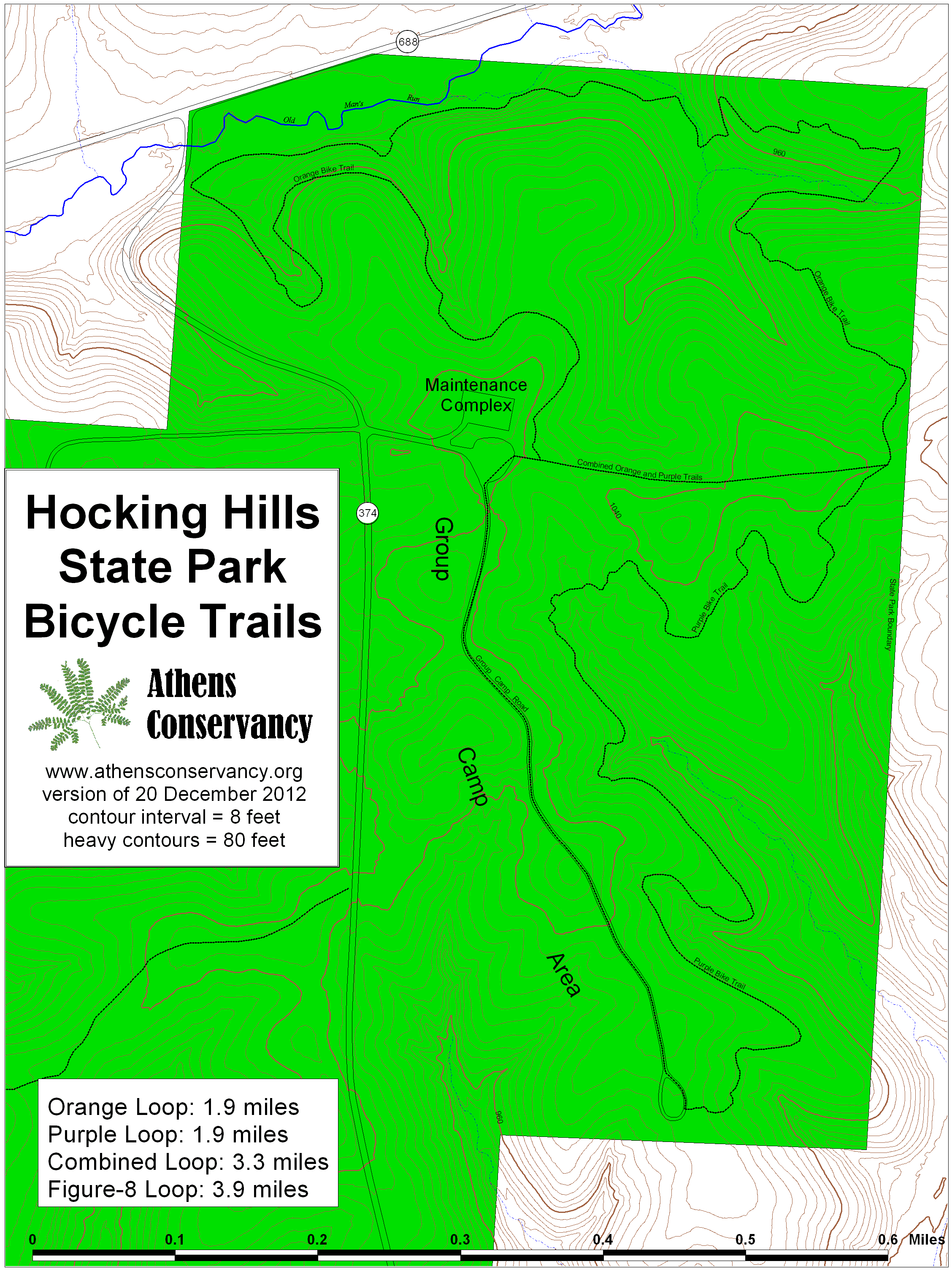
- Archery Trail: This is a quarter-mile trail, extending from the south end of the archery range (across from the Visitors Center), up the stream valley. There are 19 stations with field targets. Each field target is a carved wooden animal with a straw-stuffed target area.