

Hocking
State Forest
| Hocking State Forest at a Glance | |
| Date established: | 1924 Hocking Hills State Park separated in 1949 Conkles Hollow, Sheick Hollow, and Little Rocky Hollow State Nature Preserves separated in 1976 |
| Acreage (total): | 9,696 acres (3,926 hectares) |
| Miles of trails: | 57 miles (91 kilometers) There are a total of about 76 miles of trails altogether in the Hocking Hills, including the state forest, state park, and Conkles Hollow. |
| Trail miles open to horses: | 44 miles (70 kilometers) |
| Campsites: | Horse camp only in state forest, but others available in adjacent Hocking Hills State Park |
| Hunting: | All hunting allowed (other than safety zones) |
| Special features: | Dedicated rock-climbing area |
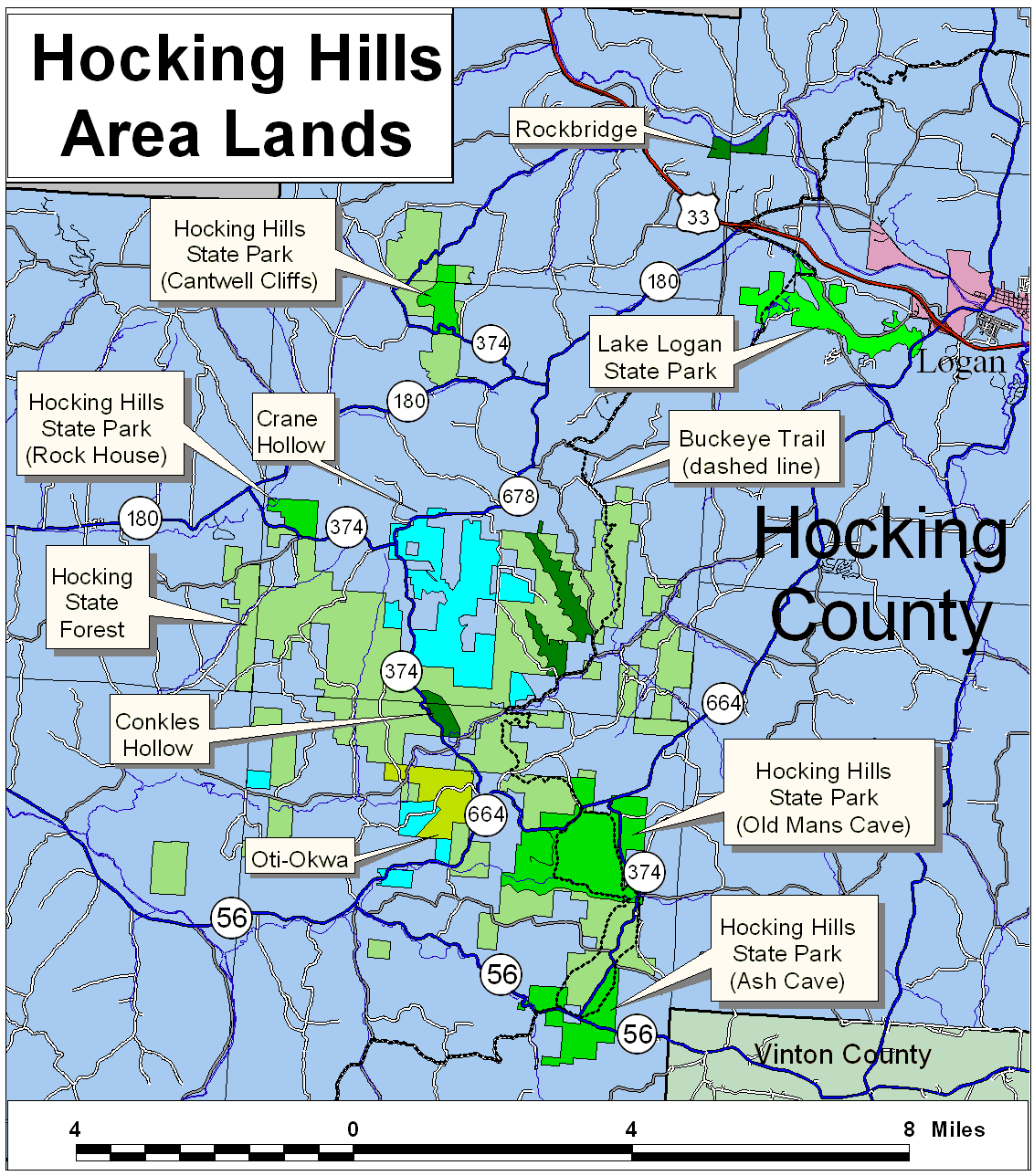
| Adjacent natural areas: | Hocking Hills State Park Conkles Hollow State Nature Preserve |
| Nearby natural areas: | Lake Logan State Park Rockbridge State Nature Preserve |
| Official state forest website: | http://forestry.ohiodnr.gov/hocking |
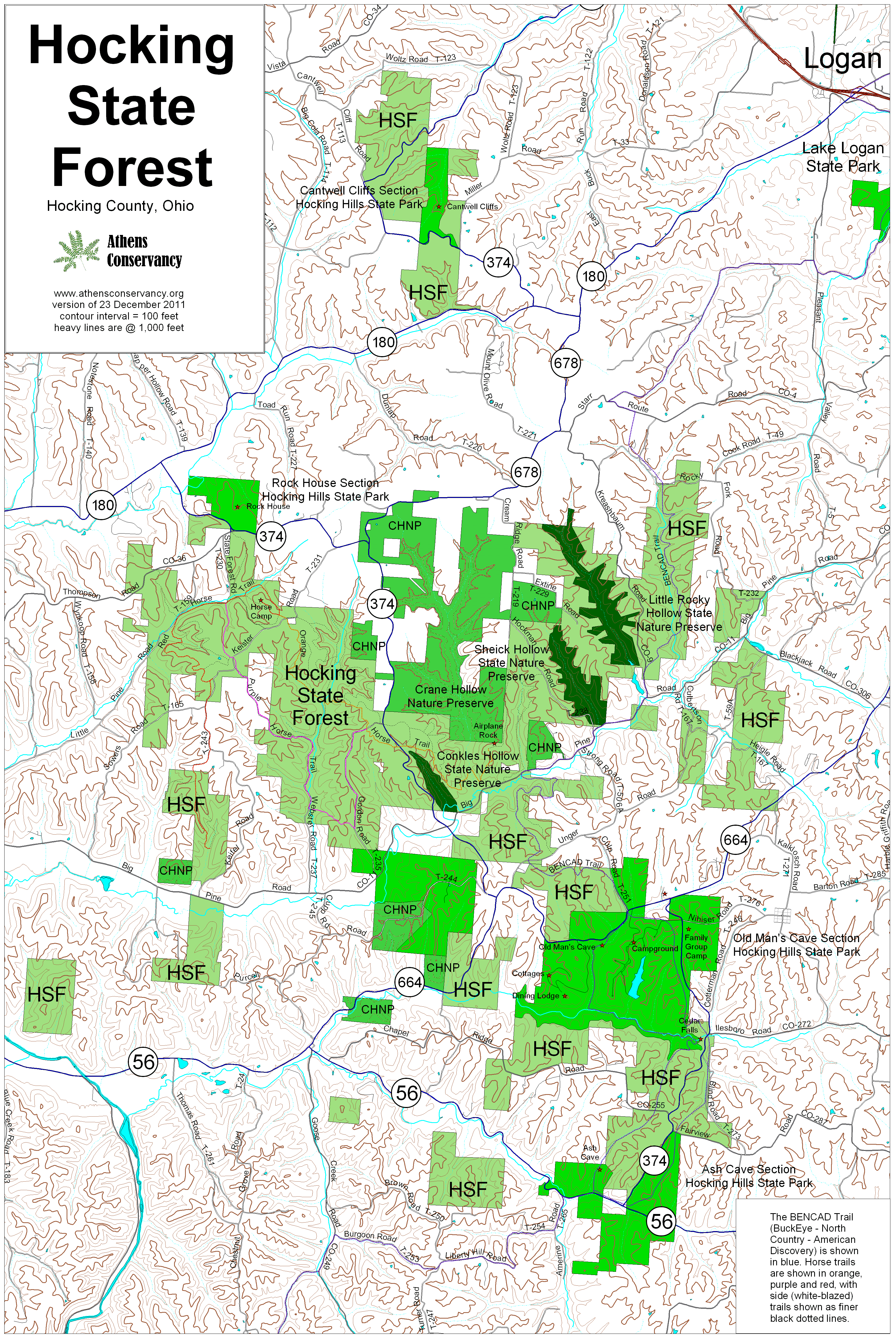
This state forest is not as consolidated as many of them are, but is spread over a considerable area. However, much of the intervening land has been purchased as a private nature preserve, known as Crane Hollow.

Trails at Hocking State Forest
Hocking State Forest hosts two trail sets: horse trails, and a portion of the BENCAD Trail. The list, below, is of the horse trails:- Orange Trail: 4.5 miles
- Purple Trail: 4.6 miles
- Red Trail: 5.1 miles
- White side trails: 19 miles
For more details on trails, see Trails at the Hocking Hills.
Directions
To get to Hocking State Forest from Athens, take US-33 about 28 miles west from OH-550/Columbus Road at Athens to OH-180. Exit and turn left on OH-180. Take it four miles south to OH-678. Turn left on OH-678 and go four miles to OH-374.Horse Camp: From this point, turn right on OH-374 and go 0.4 mile to Keister Road, Township Road 231. Turn left on Keister Road and go one mile to the access road to the horse camp, which will be on the right. Turn right on that road, and the horse camp is another 0.1 mile or so.
Total driving distance from downtown Athens to the horse camp: 40.5 miles.
Rock-climbing area: To reach the rock-climbing area, take US-33 west 24.2 miles from OH-550 into Hocking County to OH-664. Turn left on OH-664 and go 4.2 miles to Big Pine Road. Turn right and go 5.7 miles to the rock-climbing area parking (on the right).
Total driving distance from downtown Athens to the rock-climbing area: 36.9 miles
BENCAD Trail parking: To reach the BENCAD trail parking, take US-33 west 24.2 miles from OH-550 into Hocking County to OH-664. Turn left on OH-664 and go 4.2 miles to Big Pine Road. Turn right and go 4.1 miles to Kreashbaum Road. Turn right and go 0.4 mile to the parking area (on the right).
Total driving distance from downtown Athens to BENCAD trail parking: 35.7 miles
Note: Horse trails shown on the map below were interpreted from available state literature, and have not as yet been field-checked. They are probably highly inaccurate. Other trails shown are accurate.